Terrain Analysis Rendering Pipeline
How Slope, Aspect, Curvature and friends turn a raster-dem source into a colored layer
This page covers the mechanism — how a *-protocol.ts file gets from an upstream raster-dem tile to a rendered layer. For what each mode means geomorphologically, see Terrain Visualization Modes; for the exact formulas, see Equations & Formulas.
Slope is the reference implementation, but the same pipeline shape covers Aspect, Curvature (and its Profile/Plan/Det-Hessian/Casorati/Shape-Index sub-modes), TRI, TPI, Roughness, Blobness (and its Eigen-Ratio/Orientation sub-modes), Sky-View Factor, Openness, and Local Dominance — eleven modes, three files' worth of shared plumbing, one formula each. LRM and the Lighting Effects modes (Matcap/Phong/Hard Shadows) genuinely diverge — see LRM and Lighting Effects.
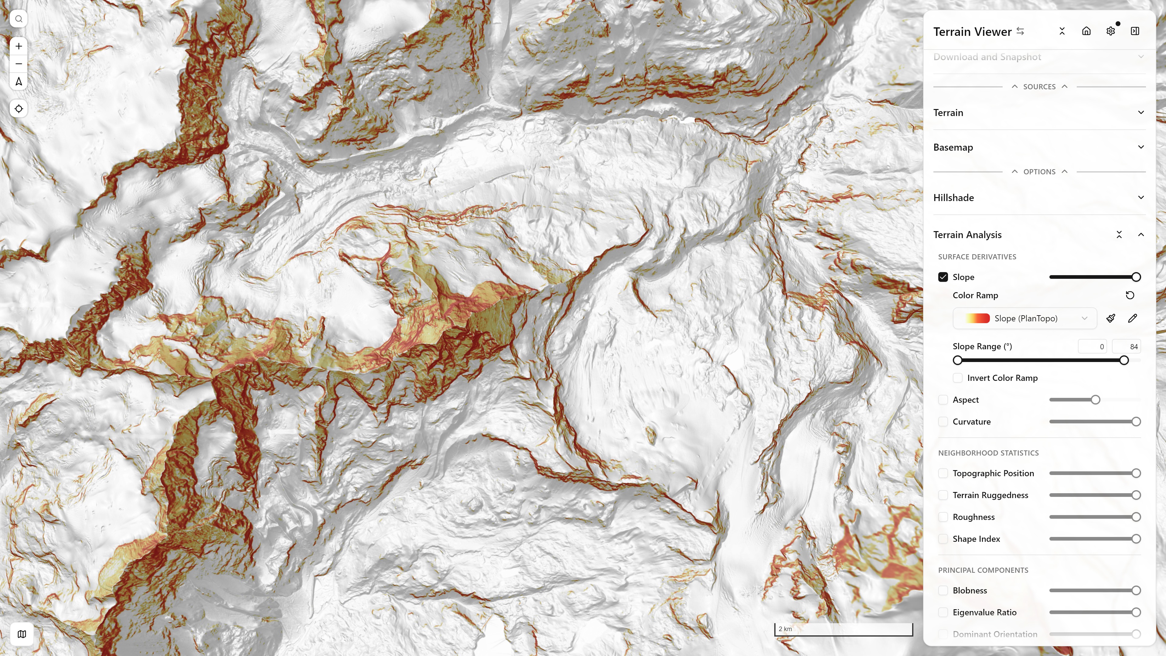
Slope + Hillshade backdrop — Matterhorn massif — open in app ↗
1. Source fetch
Each mode is a MapLibre custom protocol (slope://, aspect://, curvature://, tri://, tpi://, roughness://, blobness://, svf://, openness://, local-dominance://) whose tile URL embeds the upstream raster-dem tile template plus {z}/{x}/{y}. On a tile request, the handler fetches the center tile and its 8 same-zoom neighbors concurrently — needed so the kernel at a tile's edge pixels has real neighbor data rather than a clamped repeat. All of them (and Slope, Aspect, TRI, Curvature, TPI, Roughness, Normals, Matcap, Phong specifically) share one LRU sharedTileCache, so turning on several derived layers at once still decodes each upstream tile exactly once.
2. Decoding elevation
Each fetched tile's RGBA is decoded to a Float32Array using the upstream's encoding — either Terrarium or Mapbox Terrain-RGB (lib/elevation-encoding.ts):
3. Stitching a padded neighborhood grid
The 9 decoded tiles are stitched into one padded (n + 2·halo) × (n + 2·halo) grid, edge-replicated where a neighbor is missing (world edges, poles, a failed fetch). Most modes use halo = 1 — a plain 3×3 window (a0..a8, GDAL's row-major convention). Blobness uses halo = 2 (5×5) because its structure tensor needs a Horn gradient computed at each of the 9 sub-cells around the output pixel, not just once at the center. SVF/Openness/Local Dominance instead march rays outward up to a user-set search radius (see below), so their halo is that radius, not a fixed 1 or 2.
4. The kernel
- Slope, Aspect, TRI, TPI, Roughness, Curvature all reuse the same Horn 3×3 gradient (
hornGradient()inlib/normal-derived-protocol.ts, ported from GDAL'sGDALSlopeHornAlg), Mercator-corrected bycos(tileCenterLat)so the ground-distance denominator is real, not the nominal equator-only pixel size. - Blobness / Eigen-Ratio / Orientation build a Förstner/Harris structure tensor from 9 Horn gradients (one per sub-cell of the 3×3 window) and read off
det/trace, the eigenvalue ratio, or the principal eigenvector's axis. - SVF / Openness / Local Dominance march outward in 8 compass directions (
lib/horizon-angle.ts) rather than sampling a fixed-size window — see that file's own precision/performance tradeoffs (fixed 8 directions, integer-pixel steps, an optional "fast" power-of-two-radius approximation).
The exact per-mode formulas are on the Equations page; this page is about what happens to the result once it's computed.
5. Output encoding — the key architectural trick
The computed scalar is not rendered directly to RGBA color. It's re-packed as a pseudo-elevation, using the exact same byte-packing MapLibre's native raster-dem decoder already knows how to read:
// lib/tri-protocol.ts (representative — every mode in this family ends the same way)
const [r, g, b, alpha] = elevationToTerrarium(computeValue(window))
outData[idx] = r; outData[idx + 1] = g; outData[idx + 2] = b; outData[idx + 3] = alpha
Slope uses Mapbox Terrain-RGB packing (base −10000, 0.1 unit step — plenty of precision for a 0–90° angle); every other mode uses Terrarium packing (~0.0039 step) because their values cluster near zero and would visibly band under Terrain-RGB's coarser step. Curvature additionally multiplies by an internal CURVATURE_ENCODE_SCALE = 1000 before encoding (undone when the raw value is read back for the UI/ramp bounds) purely to spread its small, near-zero-heavy range across more of Terrarium's discrete levels.
Those packed bytes are then handed to maplibre as an ImageBitmap, via the shared toTileImage tail in lib/tile-image.ts — not PNG-encoded. That choice is worth three orders of magnitude per tile and is the subject of the last section on this page.
6. MapLibre consumption
The resulting bitmap is added as an ordinary type: "raster-dem" <Source> — e.g. SlopeSource in components/LayersAndSources/MapSources.tsx:
<Source id="slopeSource" type="raster-dem" tiles={[url]} tileSize={256} encoding="mapbox" />A type="color-relief" <Layer> (SlopeReliefLayer and its siblings in MapLayers.tsx) then reads that source through MapLibre's native ["elevation"] expression and a color-relief-color interpolate expression built from a ramp in lib/color-ramps.ts (slope-plantopo, tri-default, curvature-diverging, blobness-default, …):
<Layer id="color-relief" type="color-relief" source="hillshadeSource" paint={colorReliefPaint} />So: the derivative value is smuggled through the raster-dem pixel format, and MapLibre's own color-relief machinery does the decode-and-color step. None of these protocol handlers hand-roll an RGBA colormap themselves — the same computeColorReliefPaint helper that colors real hypsometric elevation tint also colors slope degrees, curvature, TRI, and every other mode here, because to MapLibre they're indistinguishable from elevation.
7. Registration
Every protocol is registered once, at app init, in components/TerrainViewer.tsx, through the protocol registry:
registerProtocol('slope', withTileResultCache(slopeProtocol))
registerProtocol('tri', withTileResultCache(triProtocol))
registerProtocol('svf', withTileResultCache(withSlowTileStats('svf', svfProtocol)))
// …one line per mode
withTileResultCache wraps the raw handler with its own result cache (on top of the shared decoded-tile cache from step 1); withSlowTileStats (SVF/Openness/Local Dominance only — the more expensive ray-marched modes) records timing for the app's internal perf instrumentation.
registerProtocol (lib/protocol-registry.ts) registers the scheme with MapLibre and also lets every other consumer in the app dispatch to it: step 1 of this pipeline reads its upstream through the registry, which is why every mode works over vrt://, lerc://, demdiff:// and the rest. What a custom protocol is, the full list of schemes and the registry's rules are on Custom Protocols.
GPU acceleration — none here
Computation for all eleven modes on this page is pure CPU/JS on the main thread, per tile — nothing here touches a GPU, and OffscreenCanvas appears only in the fallback encode path described in step 5, never in the compute. runWindowedProtocol/runNormalDerivedProtocol explicitly yield every YIELD_EVERY_ROWS rows so a burst of new tiles during a pan/zoom doesn't block input handling. For scale: LRM over a z13 viewport is about 1.2 s of recompute, which is why finished tiles are cached rather than recomputed on every toggle (see Tile Caches). The only GPU path in the codebase is computeNormalPixelsGPU (WebGL2), used exclusively by lib/normals-protocol.ts for the surface-normal computation that backs Matcap and Phong — see Lighting Effects.
Does this apply to Relief Visualization and Lighting too?
- Sky-View Factor, Openness, Local Dominance — yes, same output pipeline (step 5 onward). They just replace the fixed 3×3 kernel with the ray-marched horizon-angle core in
lib/horizon-angle.ts(SVF/Openness) or a pyramid-sampled downward-angle average (Local Dominance, which borrows LRM's ancestor-tile trick for its far field — see LRM). - LRM — no. It isn't a function of one same-zoom neighborhood at all; it subtracts a coarser pyramid ancestor tile from the fine tile. See the dedicated LRM page.
- Matcap, Phong, Hard Shadows — no. These start from a real
(nx, ny, nz)surface normal (optionally GPU-computed) rather than a pseudo-elevation scalar, and matcap/phong end as plaintype: "raster"(notraster-dem/color-relief) layers, with an additional live-WebGL fast path that bypasses the protocol round-trip entirely for parameter changes. See Lighting Effects.
Handing the tile back to MapLibre
Every mode on this page ends in the shared toTileImage tail (lib/tile-image.ts), which returns an ImageBitmap. That is a recent change, and the reason is worth spelling out, because the same trap is laid for anyone writing an addProtocol handler.
Why it matters
The alternative tail — the one you write if you follow the docs — is:
const blob = await canvas.convertToBlob({ type: "image/png" })
return { data: new Uint8Array(await blob.arrayBuffer()) }
MapLibre then undoes that immediately: arrayBufferToCanvasImageSource → arrayBufferToImageBitmap. A PNG encode and a PNG decode, per tile, for nothing.
What you can write instead, if you already hold the pixels:
return { data: await createImageBitmap(new ImageData(pixels, 256, 256)) }or, if you drew into a canvas rather than filling an array yourself:
return { data: await createImageBitmap(canvas) }Both are used as-is, with no decode step. createImageBitmap is unavailable in a handful of environments (older Safari, some worker contexts), so a handler that must cover those can keep the convertToBlob path as a fallback behind a typeof createImageBitmap === "function" check.
What it cost here
Measured over 15 runs on a 256×256 tile: 99 ms median for the convertToBlob tail, with about half the runs near 1000 ms, against 0.1 ms for createImageBitmap. On every tile of every mode on this page.
MapLibre has always accepted the fast form — its image request checks for it before falling back to decoding bytes:
if (response.data instanceof HTMLImageElement || isImageBitmap(response.data)) {
    // User using addProtocol can directly return HTMLImageElement/ImageBitmap type
    onSuccess(response);
}
It simply was not advertised: the types said ArrayBuffer and the documented example showed a canvas. maplibre-gl-js #8515 and #8525 documented and typed the return shape after this was found; the timings are in Tile Caches.