Google Earth Historical (Time Machine) Protocol
How the gehist:// protocol reverse-engineers Google Earth's historical imagery, and how it's wired into this app
"Google Earth Historical" is one of the providers behind Historical Imagery mode — the one that reaches occasional very old outlier captures for well-covered areas, via a reverse-engineered protocol scaffolded from Iconem's own GE_TimeMachine. This page has two parts: the protocol itself (how Google's undocumented "Time Machine" data format actually works — universal, not app-specific) and how this app wires it in (which is app-specific and diverges from GE_TimeMachine's own standalone-demo instructions).
There is no official API for this data today, but that may change: Google's issue tracker shows they are tracking interest in official Historical Imagery API access, and activity there suggests work is being done toward offering it. In the meantime, this implementation mocks up a Google Earth Enterprise client to make the imagery viewable.
Built on
Reading Time Machine end-to-end means walking an undocumented, encrypted, protobuf quadtree protocol. GE_TimeMachine builds on several open-source projects, reusing their logic and reverse-engineering directly wherever the work is substantial:
- GEHistoricalImagery (Mbucari) — the primary reference for the
tmprotocol: theflatfile/dbRootendpoints, the quadtree walk (one packet per 4 levels followingcache_node_epoch), the sub-index math, the bit-packed date format, and the fact that Time Machine is built from thetmdatabase alone. The quadtree-path math is a direct port of itsKeyholeTile. - CesiumJS — the XOR keystream is its
decodeGoogleEarthEnterpriseDataalgorithm; itsGoogleEarthEnterpriseMetadataconfirmed the GEE quadkey digit layout. - protobuf.js — decodes every packet/dbRoot message, with one hand-written shim for the proto2 group it can't encode/decode (see §4 below).
- ESRI wayback-core — a contrasting release-chained model that helped clarify how GE's self-contained per-tile dates differ; see ESRI Wayback for how that model works and is used by this app.
- pako for zlib; MapLibre GL JS for the map and the custom-protocol API.
1. Big picture
All capture dates for a tile live in that tile's single decoded quadtree packet — no release-to-release chaining (the opposite of ESRI Wayback).
2. The Keyhole quadtree path (not Web-Mercator, not Bing)
Earth is recursively split into 4 quadrants; a tile is a path string of digits 0..3 (one per zoom level) that always starts with 0 (root).
- The grid is plate-carrée (equirectangular, EPSG:4326-style square tiling):
row = col = floor((deg + 180)/360 · 2^level), rows increasing north. This is not the EPSG:3857 Web-Mercator quadrant scheme slippy{z}/{x}/{y}tiles use — exactly why the protocol reprojects each fetched tile. - The digit is
(row_bit << 1) | (row_bit XOR col_bit). This is not the Bing/standard quadkey (x_bit | y_bit<<1) — verified over 4000 random tiles they differ ~95% of the time. Computed directly (matching GEHistoricalImagery'sKeyholeTileexactly); CesiumJS is used only for the XOR keystream, not the tiling.
3. Packets, epochs, branch nodes, and the 4-level walk
A packet (qp-{path}-q.{epoch}) bundles up to 1 + 4 + 16 + 64 + 256 = 341 nodes — a 4-level-deep sub-tree. Most nodes are leaves carrying imagery layers; some are branch nodes, sitting on the bottom (4-level) boundary of one packet and pointing to the next packet via cache_node_epoch. A node whose cache_node_epoch == 0 is a true leaf.
"Epoch" is a cache/version number, not a date — Google's way of versioning a packet so URLs are cache-bustable:
quadtree_version(from dbRoot) = the root packet's epoch.cache_node_epoch(on a branch node) = the child packet's epoch.dated_tile_epoch(on each dated tile) = the epoch that goes in the image-tile URL.
4. Protobuf + the proto2 group (a protobuf.js limitation)
QuadtreePacket.sparse_quadtree_node (field 2) is a proto2 group (framed by start-group/end-group tags, no length prefix). protobuf.js's .proto parser accepts the group keyword but its encoder/decoder never implemented group wire types — it silently treats the field as length-delimited (wire type 2), and desyncs with "invalid wire type 7" on Google's real group-encoded bytes. (Google's own C# protobuf, and Cesium's hand-rolled parser, both handle groups natively.) GE_TimeMachine hand-walks the group framing itself and decodes each inner QuadtreeNode (a normal message) with protobuf.js. Groups appear only here; everything below QuadtreeNode is ordinary length-delimited.
5. The schemas
LayerType: 0=IMAGERY, 1=TERRAIN, 2=VECTOR, 3=IMAGERY_HISTORY — this app reads only IMAGERY_HISTORY.
6. "Epoch" vs "date"
Date is QuadtreeImageryDatedTile.date, a bit-packed integer: date = (year << 9) | (month << 5) | day, decoded as year = date >> 9, month = (date >> 5) & 0x0F, day = date & 0x1F. Values ≤ 545 are sentinels and ignored. The tile URL uses this packed integer in lower-case hex: …-i.{epoch}-{date.toString(16)}.
7. Decrypt & decompress
Everything (dbRoot body, packets, tiles) is XOR-obfuscated with one keystream whose key ships in clear in encryption_data. After XOR, packets are zlib with an 8-byte header (uint32 magic 0x7468dead, uint32 uncompressed_size, then the zlib stream); image tiles are raw JPEG with no protobuf wrapper. XOR is symmetric.
8. Endpoints
Host https://khmdb.google.com, db=tm:
| purpose | URL |
|---|---|
| dbRoot (key + root epoch) | /dbRoot.v5?db=tm&hl=en&gl=us&output=proto |
| quadtree packet | /flatfile?db=tm&qp-{path}-q.{epoch} |
| dated image tile | /flatfile?db=tm&f1-{path}-i.{epoch}-{dateHex} |
Time Machine is built from tm alone — no dependency on the default Google Earth database.
How this app wires it in
The vendored protocol source lives at lib/ge-timemachine/ge-historical.js + ge-decrypt.js — a plain vendored copy (not a submodule), added in a single commit alongside the rest of the app. lib/ge-historical.ts is a thin app-side wrapper:
// lib/ge-historical.ts
let geInstance: ReturnType<typeof registerGEHistorical> | null = null

function getGe() {
  if (!geInstance) geInstance = registerGEHistorical(maplibregl, {})
  return geInstance
}
registered lazily (on first use, not at app mount) with an empty options object — no proxy, no debug flag, maxLevel left at the library default.
No CORS proxy. GE_TimeMachine's own docs (and the demo instructions above) assume khmdb.google.com needs a CORS proxy for a browser deploy. This app doesn't use one — a direct fetch() against Google's endpoints was confirmed to succeed (including a full dbRoot+tile round trip) in both dev and production, because they already send a permissive Access-Control-Allow-Origin. The library's proxyUrl/setProxy mechanism is still present in the vendored code but never invoked here.
Layer wiring and date selection. components/LayersAndSources/MapSources.tsx treats ge-historical as one branch of the basemap-source memo:
if (basemapSource === "ge-historical") {
  if (!date) return null
  return geHistoricalTileSource(date)
}
There's no imperative setDate() call — geHistoricalTileSource(dateMs) calls ge.makeRasterSource({ year, month, day }) fresh on every render, and MapLibre's <Source> diffs the resulting tiles template and re-fetches. Date itself is per-view nuqs URL state (consistent with the app's "URL as app state" architecture) — dragging a handle on the historical timeline updates that URL param, which flows down into the source memo. Available scrubber tick marks come from useGeHistoricalDates(lat, lng, zoom), which calls ge.getDatesForPath() for the real per-tile capture dates, debounced 400ms.
Attribution is split in two, since MapLibre/react-map-gl's <Source> reconciler can't live-update attribution post-mount: the source's static attribution prop is a placeholder, while the real per-tile provider (e.g. "Google Earth - CNES / Airbus") is resolved separately via useGeHistoricalDynamicAttribution and shown in the sidebar's Source Info panel.
Registries. ge-historical is registered into HISTORICAL_BASEMAP_IDS (lib/historical-sources.ts) and EXPORT_SOURCE_IDS (lib/historical-export-sources.ts), so listExportTicks("ge-historical", ...) can call the same listGeHistoricalTicksInRange/geHistoricalTileSource pair the live map uses to feed batch export (lib/export-multi.ts) without a mounted component.
Which date is drawn as you zoom
A node's date list belongs to its level. Over the Sharjah coast at Al Hamriyah the coarse nodes list only the yearly Landsat / Copernicus mosaics, and from level 14 the list is the sharp captures, with a single mosaic still hanging on (read with getDatesForPath on 2026-10-19):
| Level | Dates listed | Providers |
|---|---|---|
| 6 to 13 | 37, one per year 1984 to 2020, each dated 31 December | Landsat / Copernicus |
| 14 | 47 | Maxar 39, Airbus 5, CNES / Airbus 2, Landsat / Copernicus 1 (1985) |
| 15 to 18 | 39 to 41 | Maxar, Airbus, CNES / Airbus |
| 19 | 36 | the same, the oldest Maxar captures gone |
So a date picked on the timeline at one zoom is often absent from the node at another, and two rules decide what happens.
The tiles keep the date honest. _pickTileForPath draws the node's own capture of exactly the set date; failing that, the nearest ancestor's capture of that date, cropped and upscaled; and only when no node up to the root lists the date, the newest capture on or before it at this level (with nothing that old, the oldest). Nothing newer than the slider is ever drawn. An earlier "nearest date" pick had the view drift onto 2012 imagery while the slider said 2010.
The timeline moves the date to what is drawn. With that rule alone, a mosaic picked at a low zoom stayed blurry on zooming in: the exact 31 December date was found on an ancestor and upscaled, while sharp captures of the same year sat a tick away. Once the dates of the settled camera are in, historical-timeline-panel.tsx adjusts each Google Earth view's date, Google Earth's own "as of" behaviour:
- listed at this level: kept, the capture covers the view centre;
- listed only by an ancestor, so the view zoomed in past the imagery's levels: the newest capture on or before it here, or with nothing that old the oldest one, the same choice the tiles make;
- listed nowhere up the chain, a sharp capture seen from a coarse zoom or a typed date: kept. The tiles meanwhile show the newest mosaic on or before it, and the handle sits on that mosaic's tick; zooming back in returns to the capture, so repeated zooms never drift;
- past the newest capture here (a link saying "today"): that newest capture.
The hook useGeHistoricalDates returns the ancestors' dates beside the node's own for this; the ancestors' packets were loaded by the walk, so it costs no request. It reads the node at the level the tiles on screen are built from, not at the viewport zoom: MapLibre requests tile zoom round(zoom) + 1 for a 256 px raster source, and the HiDPI build below takes one level more, so at viewport zoom 12 the list is level 14's. Read at the viewport zoom, the timeline kept the mosaics' ticks while the tiles were already the sharp captures, and the snap came two zooms late. Neighbouring tiles that do not list the chosen capture still climb to an ancestor and draw soft, which the handle's date then explains: the capture does not cover the whole view.
Tile resolution: level z or z + 1
A Keyhole level-z tile spans 360 / 2^z degrees of longitude and of latitude in 256 px; a Mercator z tile spans that longitude but cos(lat) times that latitude. Horizontally the two grids have the same 2^z columns, so a tile built from level z is exact across. Vertically its 256·cos(lat) source rows are stretched onto 256 output rows:
| Latitude | Vertical upscale |
|---|---|
| 25° (Sharjah) | 1.10× |
| 45° (Lyon) | 1.41× |
| 49° (Paris) | 1.52× |
| 60° (Oslo) | 2.00× |
The HiDPI switch in Streaming Settings, on by default, has _buildMercatorTile take level z + 1 instead, two Keyhole columns and two or three rows, and emit a 512 px image while the source still declares tileSize: 256: MapLibre requests the same z, draws the image at 256 CSS px (a downsample below 60°, the vertical stretch gone) and a HiDPI screen shows all 512. The flag rides in the tile URL (hd=1), so toggling it changes the source's tiles and MapLibre refetches. The quadtree walk rarely grows, since a packet spans four levels; the Keyhole fetches do, four per tile instead of one. The finished-tile cache is bounded in bytes (64 MB) rather than tiles for this reason. The Export Multi mosaic keeps the 256 px build, since it lays tiles out at that size.
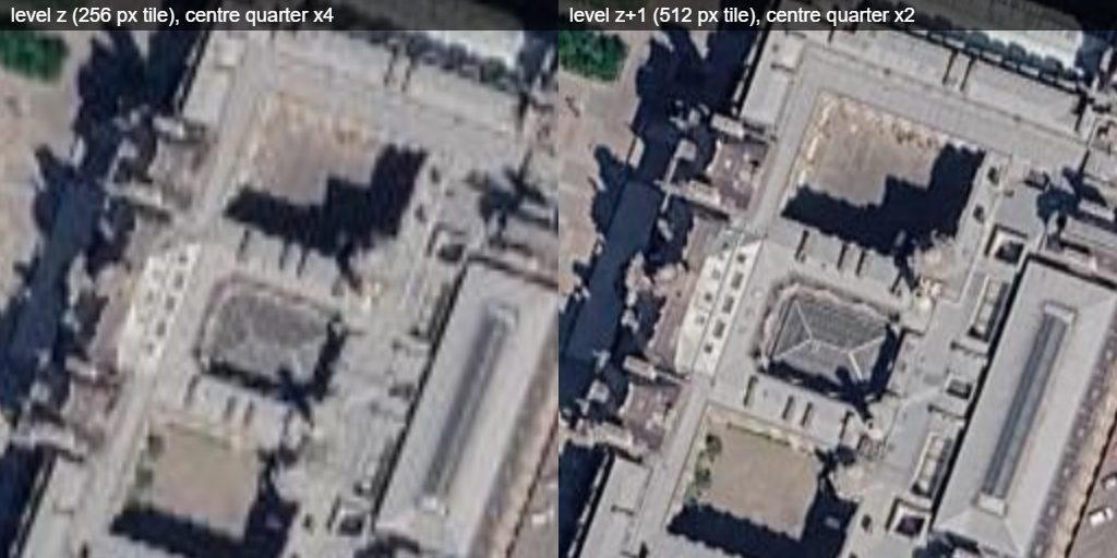
Zoom 17 over the Louvre, the newest capture, the same ground at the same output size: the centre quarter of the level-z tile (left) beside the centre quarter of the level z + 1 tile (right), read back from getMercatorTile in the browser on 2026-10-19. The build took 26 ms against 43 ms.
Limitations
- Coverage is sparse and mostly appears at higher zooms — "no dated history" for a tile is a coverage signal, not an error. At low zooms the ticks are the yearly Landsat / Copernicus mosaics, see above.
- Vertical reprojection (WGS84-square → Web-Mercator) is piecewise linear in 8 px bands — sub-pixel error at high zoom. Built from level z the tile is stretched 1 / cos(lat) vertically, see above.
- Google's endpoints are undocumented and may change without notice; request shapes mirror GEHistoricalImagery's.
Esri Wayback
How Esri's World Imagery Wayback viewer works, its release-chained dates against Google Earth Historical's per-tile ones, and how Terrain Viewer shows them. The service is Esri's at wayback.maptiles.arcgis.com, often typed as wayback.maptiler.com, which does not exist.
Google Earth Timelapse
How the gtimelapse:// protocol turns the Timelapse viewer's video tiles into yearly basemaps, and how Google builds the mosaics